Harnessing the tools for ‘true’ sustainability – 4D-GIS
Advanced tools and expertise in understanding and analysing the past, present and future material and energy requirements of our cities provide us with new opportunities to plan and create truly sustainable cities and urban systems.
Sustainable use of natural resources and low carbon development have become guiding concepts in the quest for sustainable development.
The new Sustainable Development Goals, spearheaded by the United Nations, embrace the need to conserve natural resources, reduce and recycle waste and avoid emissions – and they identify cities as a main domain of action.
Creating and operating world cities has required large quantities of accessible mineral resources, consumed massive tracts of native forests, overworked increasing areas of land for food production and stretched our water resources. In turn, this has produced copious amounts of chemical, material and greenhouse gas wastes that all affect our environment and indeed the future prospects of a range of living systems and life forms.
“Since the industrial revolution, our cities, and consumption by their people, have become ever-increasing drivers of the environmental challenges we now face,” according to Dr Heinz Schandl, a Senior Principal Scientist with CSIRO Land and Water. “Without changing current patterns, cities are unsustainable!
“However, cities are also at the heart of future solutions and the benefits that will flow from finding them. Solutions will include new, better and more efficient ways to build and run cities, to better use, recycle and re-use their component materials and resources, and to eliminate or minimise unusable wastes.”
“The Sustainable Development Goals will only be achieved if we can globally reduce the amount of material, energy, waste and greenhouse gas emissions required for a good quality of life,” according to Dr Schandl, who is a member of the United Nations Environment Programme (UNEP) International Resource Panel and lead author of the United Nations-commissioned Global Material Flows and Resource Productivity.
“The way we design and construct cities is crucial and yet there is limited understanding of the metabolic consequences of urban development.”
Urban and industrial metabolism have become key terms in environmental accounting. They refer to the scientific metaphor of industrial ecology. In biology, metabolism refers to the processes and chemical reactions that enable living organisms to grow, produce energy, reproduce, eliminate waste and sustain life.
Much like living systems or organisms, cities use and consume resources, digest and transport chemicals, manage a wide range of processes, produce and use energy, grow, evolve and create or eliminate wastes.
Differently from biological systems, cities can “intervene” in processes of metabolism and plan and organise their resource and waste flows, according to Dr Schandl. “Improvements in the design and location of buildings, in transport systems and other infrastructure can have a lasting legacy for the resource efficiency and climate and environmental impacts of a city.”
Such planning requires new information that goes beyond economic data and looks at resource flows in a comprehensive and geographically explicit way.
“We need to understand how cities have evolved, how they currently perform and how they will require natural resources and produce waste and emissions in the future.
“New approaches to understanding and planning our cities can simultaneously help us realise social, economic and environmental objectives and Australia is well placed to be at the leading edge of this.”
A 4D model to guide planning
Cities like Canberra, Sydney and Melbourne have already shown a desire to push the frontiers of this type of planning and the necessary expertise already exists in the research and industrial communities, according to Dr Schandl.
“CSIRO and partners have the expertise to build four-dimensional models of cities that bring together all the relevant data to understand the past and current make-up of the city, its resource and energy use, emissions and waste streams and potential future scenarios of urban development based on resource efficiency and waste and emission minimisation.”
Four-dimensional geographic information system (4D-GIS) models can provide a wealth of information to guide urban planning in specific locations and also at the city scale. They help in identifying the material and energy requirements of urban renewal strategies, and allow assessment of the metabolic consequences of an urban plan. Such models also highlight emerging economic opportunities based on better knowledge of waste streams and their material composition. Traditional 3D modelling encompasses spatial parameters (latitude, longitude and altitude); time is the fourth dimension in a 4D model, considering past data and allowing future projections.
4D-GIS has been applied in case studies in Wakayama (Japan), Padua (Italy) the greater Manchester (Salford) area (UK) and in determining waste flows and material use opportunities in Nagoya (Japan) and a district of Shenyang city (China).
For past and existing urban infrastructure, a 4D-GIS model can include information on:
- material content of above-and below-ground structures including for concrete, iron and steel, copper, bricks, timber, glass, and other categories
- lifetime and demolition timeframes
- embodied material, energy and carbon emissions
- operational energy use and carbon emissions
The approach estimates future demolition waste flows including material characteristics and volumes.
“Such a model enables environmental best practice to be applied for current and emerging urban infrastructure,” Dr Schandl says.
“For example, at a greenfield site like Ginninderra we could use 4D-GIS to map and project sustainable resource flows, recycling, and environmental management benefits as the development unfolds. The model could guide economic opportunities and provide a framework for positive and complementary relationships with neighbouring communities, the city and its environment.”
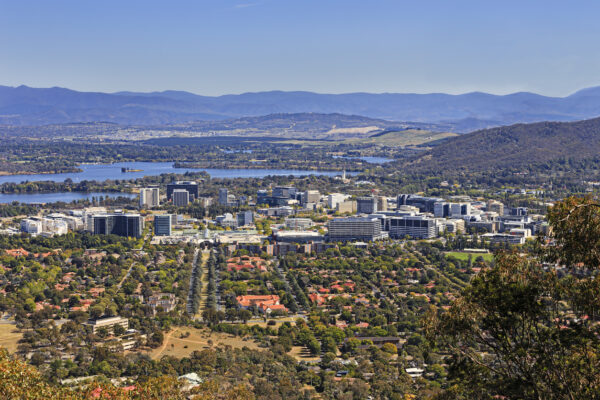
Canberra is a uniquely planned city with potential to push urban design and planning frontiers.
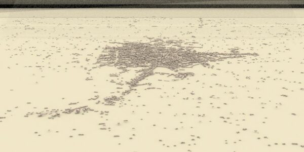
GIS models show growth and compositional changes in the Italian city of Padua spanning 105 years – 1902. Source: Tanikawa Laboratory, Graduate School of Environmental Studies, Nagoya University, Japan.
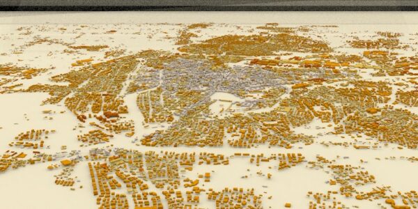
Padua in 1981. Source: Tanikawa Laboratory, Graduate School of Environmental Studies, Nagoya University, Japan.
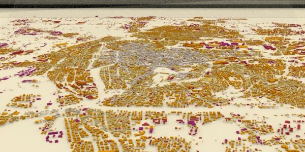
Padua in 2007. Source: Tanikawa Laboratory, Graduate School of Environmental Studies, Nagoya University, Japan.